
Groundwater Glosssary
-
Aeration Zone
The zone immediately below the land surface where the pores contain both water and air, but are not totally saturated with water. Plant roots can capture the moisture passing through this zone, but it cannot provide water for wells. Also known as the unsaturated zone or vadose zone.
-
Aquifer
An underground geological formation of sand, soil, gravel and rock able to store and yield water.
-
Artesian Aquifer
See confined aquifer.
-
Artesian Well
A well tapping a confined aquifer. Water in the well rises above the top of the aquifer under artesian pressure, but does not necessarily reach the land surface; a flowing artesian well is a well in which the water level is above the land surface.
-
Baseflow
Streamflow coming from groundwater seepage into a stream or river. Groundwater flows underground until the water table intersects the land surface and the flowing water becomes surface water in the form of springs, streams/rivers, lakes and wetlands. Baseflow is the continual contribution of groundwater to rivers and is an important source of flow between rainstorms.
-
Best Management Practices (BMPs)
Structural, nonstructural, and managerial techniques recognized to be the most effective and practical means to reduce surface water and groundwater contamination while still allowing the productive use of resources.
-
Biodegradable
Capable of being broken down by living things like microorganisms and bacteria
-
Brackish Water
Mixed fresh and salt water.
-
Capillary Water
Water located just above the water table, in the aeration zone, that moves upward from the water table by capillary action. This water can move slowly and in any direction. While most plants rely upon moisture from precipitation that is present in the unsaturated zone, their roots may also tap into capillary water or into the underlying saturated zone.
-
Compost
Fertilizing material consisting of organic, decaying matter
-
Condensation
Stage of the water cycle when water transforms from a vapor into a liquid and becomes suspended in the atmosphere, visually represented by clouds; the opposite of evaporation.
-
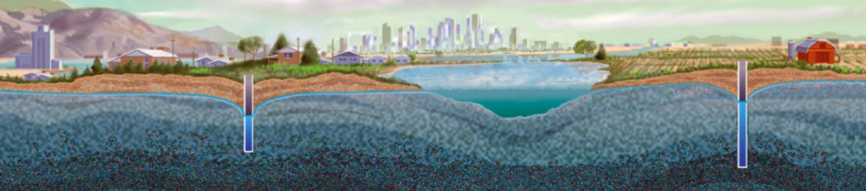
Cone of Depression
The zone around a well in an unconfined aquifer that is normally saturated, but becomes unsaturated as a well is pumped, leaving an area where the water table dips down to form a cone shape. The shape of the cone is influenced by porosity and the water yield or pumping rate of the well. The land surface overlying the cone of depression is referred to as the area of influence.
-
Confined Aquifer
An aquifer that exists where the groundwater is bounded between layers of impermeable substances like clay or dense rock. When tapped by a well, water in confined aquifers is forced up, sometimes above the soil surface. This is how a flowing artesian well is formed. Also known as artesian or pressure aquifers.
-
Confining Layer
Geologic material with little or no permeability or hydraulic conductivity such as clay or dense rock. Water does not pass through this layer or the rate of movement is extremely slow.
-
Conservation
The use of water-saving methods to reduce the amount of water needed for homes, lawns, farming, and industry, and thus increasing water supplies for optimum long-term economic and social benefits; not wasting, using something wisely.
-
Consolidated Rock
Tightly bound geologic formation composed of sandstone, limestone, granite, or other rock.
-
Consumptive Use
The use of a resource that reduces the supply (removing water from a source like a river, lake or aquifer without returning an equal amount). Examples include the intake of water by plants, humans, and other animals and the incorporation of water into the products of industrial or food processing.
-
Contamination
Substances in air, soil or water that makes it impure and unfit for consumption or an intended use, and can cause harm to human health or the environment. Contaminants can be naturally-occurring or caused by humans.
-
Depletion
The loss of water from groundwater aquifers or surface water reservoirs at a rate greater than that of recharge; when water is used faster than it is replaced.
-
Diffusion
The movement of a substance from an area of high concentration to an area of low concentration.
-
Discharge
An outflow of water from a stream, pipe, groundwater aquifer, or watershed; the opposite of recharge.
-
Discharge Area
The area or zone where groundwater emerges from the aquifer. The outflow maybe into a stream, lake, spring, wetland, etc.
-
Drawdown
A lowering of the groundwater level caused by pumping.
-
Drought
An extended period of dry weather with little or no precipitation; often affects crop production and availability of water supplies.
-
Erosion
The wearing down or washing away of the soil and land surface by the action of water, wind, or ice.
-
Evaporation
The conversion of a liquid (water) into a vapor (a gaseous state), usually through the application of heat energy during the hydrologic cycle; the opposite of condensation.
-
Evapotranspiration
The loss water from the soil through both evaporation and transpiration from plants; also referred to as ET.
-
Fertilizer
Any chemical used to improve soil and promote plant growth
-
Filtering
The soil's ability to dilute substances by retaining chemicals or dissolved substances on the soil particle surface, transforming chemicals through microbial biological processing, slowing movement, and capturing solid particles.
-
Flow Rate
The time required for a volume of groundwater to move between points. Groundwater typically moves very slowly—sometimes as little as inches per year.
-
Fresh Water
Water with less than 0.5 parts per thousand dissolved salts.
-
Gaining Stream
A stream in which groundwater discharges contribute significantly to the streamflow volume. The same stream could be both a gaining stream and a losing stream, which recharges the groundwater system, depending on the conditions.
-
Gas (Gaseous)
See vapor.
-
Gray Water
Domestic wastewater composed of wash water from household sinks, tubs, and washers.
-
Groundwater
Water contained under the ground's surface, located in the spaces between soil particles and in the cracks of sand, gravel, and rock; a natural resource and source of water for drinking, irrigation, recreation, and industry.
-
Groundwater Basin
The underground area from which groundwater drains. The basins could be separated by geologic or hydrologic boundaries.
-
Groundwater Divide
The boundary between two adjacent groundwater basins, which is represented by a high point in the water table.
-
Groundwater Flow
The movement of groundwater beneath the earth's surface
-
Groundwater Under the Direct Influence (UDI) of Surface Water
A groundwater source located close enough to nearby surface water, such as a river or lake, to receive direct surface water recharge. Since a portion of the groundwater source’s recharge is from surface water, the groundwater is at risk of contamination from pathogens such as Giardia lamblia and viruses, which are not normally found in groundwater.
-
Hydrogeology
The study of the interrelationships of geologic materials and processes with water, especially groundwater.
-
Hydrologic Cycle
The never-ending movement of water through the atmosphere, ground and back again through its various states (vapor, liquid, solid); also known as the water cycle.
-
Hydrology
The study of the occurrence, distribution, and chemistry of all waters of the earth.
-
Impermeable Layer
A layer of material (such as clay) in an aquifer through which water does not pass.
-
Infiltration
Flow of water from the land surface into the subsurface; also known as recharge.
-
Infiltration Rate
The quantity of water that enters the soil surface in a specified time interval. Often expressed in volume of water per unit of soil surface area per unit of time.
-
Injection Well
A well constructed for the purpose of injecting treated water, often wastewater, directly into the ground. Water is generally forced (pumped) into the well for dispersal or storage into a designated aquifer. Injection wells are generally drilled into aquifers that are not used as a drinking water source, unused aquifers, or below freshwater levels.
-
Integrated Management
Any combination of physical, technical, administrative, and legal practices relating to surface water and groundwater in a manner designed to increase combined benefits or achieve a more equitable apportionment of benefits from both sources. Also referred to as conjunctive use.
-
Irrigation
The controlled application of water to crops and turf areas to supplement that supplied by nature.
-
Karst
A geologic formation of irregular limestone deposits that dissolve forming sink holes, underground streams, and caverns.
-
Landfill
A low area of land that is filled in with layers of garbage and soil.
-
Leachate
Liquids that have percolated through a soil and that carry substances in solution or suspension.
-
Leaching
The process by which soluble materials in the soil, such as salts, nutrients, pesticide chemicals, or contaminants, are washed into a lower layer of soil or are dissolved and carried away by water.
-
Liquid
Water's state in the hydrologic cycle in which molecules move freely among themselves but do not separate like those in a vapor/gaseous state.
-
Losing Stream
Losing stream: A stream that is losing water to (or recharging) the groundwater system. The same stream could be both a gaining stream (in which groundwater discharge contributes to streamflow) and a losing stream, depending on the conditions.
-
Maximum Contaminant Level (MCL)
Designation given by the U.S. Environmental Protection Agency (EPA) to drinking water standards promulgated under the Safe Drinking Water Act. A MCL is the greatest amount of a contaminant allowed in drinking water without causing a risk to human health.
-
Monitoring Well
A non-pumping well, generally of small diameter, that is used to measure the elevation of a water table or water quality. A piezometer, which is open only at the top and bottom of its casing, is one type of monitoring well.
-
Municipal Water System
A network of pipes, pumps, and storage and treatment facilities designed to deliver potable water to homes, schools, businesses, and other users in a city or town and to remove and treat waste materials.
-
Nonpoint Source Pollution
Pollution discharged over a wide land area, not from one specific location. This type of pollution is caused by sediment, nutrients, organic and toxic substances originating from land use activities which are carried to lakes and streams by surface runoff. It occurs when rainwater, snowmelt, or irrigation washes off plowed fields, city streets, or suburban backyards. As this runoff moves across the land surface, it picks up soil particles and pollutants, such as nutrients and pesticides.
-
Overwithdrawal
Withdrawal (removal) of groundwater over a period of time that exceeds the recharge rate of the supply aquifer. Also referred to as overdraft or mining the aquifer.
-
Percolation
(1) The movement of water through the openings in rock or soil. (2) The entrance of a portion of the streamflow into the channel materials to contribute to groundwater replenishment.
-
Permeable Layer
A layer of porous material (rock, soil, unconsolidated sediment); in an aquifer, the layer through which water freely passes as it moves through the ground.
-
Permeable/Permeability
Capable of transmitting water (porous rock, sediment, or soil); the rate at which water moves through rocks or soil.
-
Plume
An underground pattern of contaminant concentrations in groundwater created by the movement of groundwater beneath a contaminant source. Contaminants spread mostly laterally in the direction of groundwater movement. The source site has the highest concentration, and the concentration decreases away from the source.
-
Point Source Pollution
Pollution discharged from any identifiable point, including pipes, ditches, channels, sewers, tunnels, and containers of various types.
-
Pollution
An alteration in the character or quality of the environment, or any of its components, that renders it less suited for certain uses. The alteration of the physical, chemical, or biological properties of water by the introduction of any substance that renders the water harmful to use. See also contamination
-
Pore Space
Openings between geologic material found underground. Also referred to as void space or interstices.
-
Porosity
The ratio of the volume of void or air spaces in a rock or sediment to the total volume of the rock or sediment. The capacity of rock or soil to hold water varies with the material. For example, saturated small grain sand contains less water than coarse gravel.
-
Potable Water
Water of a quality suitable for drinking.
-
Precipitation
Stage of the water cycle when water vapor molecules become too large and heavy to remain in the atmosphere and fall to the ground in the form of rain, snow, sleet, hail, etc.
-
Recharge
Water added to a groundwater aquifer. For example, when rainwater seeps into the ground. Recharge may occur naturally through precipitation or surface water or artificially through injection wells or by spreading water over groundwater reservoirs. See also infiltration.
-
Recharge Rate
The quantity of water per unit of time that replenishes or refills an aquifer.
-
Recharge Zone or Area
An area where permeable soil or rock allows water to seep into the ground to replenish an aquifer.
-
Reclaimed Wastewater
Treated wastewater that can be used for beneficial purposes, such as irrigating certain plants.
-
Recycle
To produce a new item from an old item; to reuse parts of
-
Recycled Water
Water that is used more than one time before it passes back into the natural hydrologic system.
-
Remediation
Containment, treatment or removal of contaminated groundwater. May also include containment, treatment or removal of contaminated soil above the water table.
-
Residence Time
Period of time that groundwater remains in an aquifer.
-
Return Flow
(1) That part of a diverted flow that is not consumptively used and returned to its original source or another body of water. (2) Irrigation water that is applied to an area and which is not consumed in evaporation or transpiration and returns to a surface stream or aquifer.
-
Runoff
Water that flows over the land to surface streams, rivers, and lakes.
-
Safe Yield
The annual amount of water that can be taken from a source of supply over a period of years without depleting that source beyond its ability to be replenished naturally in "wet years." Also known as sustainable yield.
-
Salt Water
Water that contains a relatively high percentage (over 0.5 parts per thousand) of salt minerals.
-
Saltwater Intrusion
Process by which an aquifer is overdrafted creating a flow imbalance within an area that results in salt water encroaching into fresh water supply.
-
Saturated Thickness
Total water-bearing thickness of an aquifer.
-
Saturation Zone
The portion below the earth's surface that is saturated with water. The upper surface of this zone, open to atmospheric pressure, is known as the water table.
-
Seepage
(1) The slow movement of water into or out of a body of surface or subsurface water. (2) The loss of water by infiltration into the soil from a canal, ditch, lateral, watercourse, reservoir, storage facility, or other body of water, or from a field.
-
Septic System
A system used to treat household sewage and wastewater by allowing the solids to decompose and settle in a tank, then letting the liquid be absorbed by the soil in a drainage field. Septic systems are used when a sewer line is not available to carry wastes to a sewage treatment plan. Also called an onsite wastewater treatment system.
-
Soil
The top layer of the earth's surface, containing unconsolidated rock and mineral particles mixed with organic material.
-
Soil Moisture
Water contained in the aeration or unsaturated zone.
-
Sole Source Aquifer
An aquifer that supplies 50% or more of the drinking water of an area.
-
Source Water Protection
Voluntary action taken to prevent the pollution of drinking water sources, including groundwater, lakes, rivers, and streams. Source water protection is developing and implementing a plan to manage land uses and potential contaminants. To be effective, source water protection should be directed to major threats to the drinking water source identified in the source water assessment. As part of the source water protection plan, a contingency plan for use in the event of an emergency is developed. Source water protection for groundwater is also called wellhead protection.
-
Spring
The emergence of groundwater at the land surface, usually at a clearly defined point; it may flow strongly or just seep out.
-
Static Water Level
(1) Elevation or level of the water table in a well when the pump is not operating. (2) The level or elevation to which water would rise in a tube connected to an artesian aquifer or basin in a conduit under pressure.
-
Storage Tank
Container that stores potentially hazardous chemicals above or below ground
-
Storm Drain
Constructed opening in a road system through which runoff from the road surface flows into an underground system.
-
Stormwater
Runoff generated when precipitation from rain and snowmelt flows over land or impervious surfaces and does not percolate into the ground. As the water flows over the land or impervious surfaces such as streets, parking lots, and rooftops, it accumulates debris, chemicals, sediment, or other potential pollutants that could adversely affect water quality if the runoff is discharged into water bodies untreated.
-
Stratum (pl: Strata)
A layer within the earth’s crust that generally consists of the same kinds of soils or rock material.
-
Subsidence
A depression of the land surface as a result of groundwater being pumped. Cracks and fissures can appear in the land. Subsidence is virtually an irreversible process.
-
Surface Water
Water above the surface of the land, including lakes, rivers, streams, ponds, floodwater, and runoff.
-
Transmissivity
A measure of the capability of the entire thickness of an aquifer to transmit water. Also known as coefficient of transmissivity.
-
Transpiration
The process by which water absorbed by plants (usually through the roots) is evaporated into the atmosphere from the plant surface (principally from the leaves).
-
Turbidity
A cloudy condition in water due to suspended silt or organic matter.
-
Unconfined Aquifer
An aquifer in which the water table is at or near atmosphere pressure and is the upper boundary of the aquifer. Because the aquifer is not under pressure the water level in a well is the same as the water table outside the well.
-
Unconsolidated Rock
Loosely bound geologic formation composed of sands and gravel.
-
Vapor
The state of water in the hydrologic cycle in which individual molecules are highly energized and move about freely; also known as gas/gaseous.
-
Wastewater
Water that contains unwanted materials from homes, businesses, and industries; a mixture of water and dissolved or suspended substances.
-
Wastewater Treatment
Mechanical or chemical processes used to modify the quality of wastewater in order to make it more compatible or acceptable to humans and the environment.
-
Water (H2O)
An odorless, tasteless, colorless liquid made up of a combination of hydrogen and oxygen. Water forms streams, lakes, and seas, and is a major constituent of all living matter.
-
Water Cycle
See hydrologic cycle.
-
Water Quality
The chemical, physical, and biological characteristics of water with respect to its suitability for a particular use.
-
Water Table
The top of an unconfined aquifer; indicates the level below which soil and rock are saturated with water. The top of the saturation zone.
-
Water Treatment Plant
A facility that treats water to remove contaminants so that it can be safely used.
-
Water-bearing Rocks
Types of rocks that can hold water, including sedimentary deposits (sand and gravel), channels in carbonate rocks (limestone), lava tubes or cooling fractures in igneous rocks, and fractures in hard rocks.
-
Watershed
The land area from which surface runoff drains into a stream, channel, lake, reservoir, or other body of water; also called a drainage basin.
-
Well
A bored, drilled or driven shaft, or a dug hole whose depth is greater than the largest surface dimension and whose purpose is to reach underground water supplies to inject, extract or monitor water.
-
Well Closure
The process of sealing a well that is no longer being used to prevent groundwater contamination and harm to people and animals.
-
Well Field
An area in which productive wells are drilled.
-
Well Siting
Location of a well placed to best protect water quality, access adequate water quantity, and allow for inspection and maintenance of the well.
-
Wellhead Protection Area
A protected surface and subsurface zone surrounding a well or well field supplying a public water system to keep contaminants from reaching the well water.
-
Wetlands
Areas where water saturation is the dominant factor in determining the nature of soil development and the types of plant and animal communities. Other common names for wetlands are sloughs, ponds, and marshes.
-
Withdrawal
The removal of water from a surface or groundwater source for use.
-
Xeriscaping
An environmentally-friendly form of landscaping that uses a variety of indigenous and drought-tolerant plants, shrubs, and ground cover.